iMaQs in Manitoba
Manitoba is blessed with a variety of rich mineral deposits, therefore mining exploration and quarrying development plays a significant role in the provincial economy. Like many other jurisdictions in Canada, the province is taking a 21st century approach to mining by transitioning from traditional ground staking and paper-based administration to an internet-based online map staking system. This approach creates a lighter environmental footprint, levels the playing field for prospectors, and promotes a positive administrative environment for increased mining exploration and development activity across the province.
The Challenge
Since 2005 Manitoba has been working toward a more efficient method of providing the mining industry with information and an effective system of administering mining and quarrying business. Although system integration was at the forefront of Manitoba’s needs – in 2005 the business need was there – not all of the pieces were in place to support the vision..
Today, Innovation, Energy and Mines is doing just what the name says: it is innovating. The business transformation arm of IEM, Business Technology and Transformation (BTT) has been working toward an electronic service delivery platform which – when complete – will support the Mines Branch vision of an ‘integrated mining and quarrying system’ (iMaQs), information sharing, secure end-to-end business functionality, including payment and confirmation.
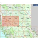
The current ground staking system, dating back to the late 19th century, is both slow and costly. It could also contribute to ongoing uncertainty with stakeholders, private land owners and Aboriginal groups, as prospectors physically venture onto the landscape without knowledge of other possible interests. In response, Manitoba recognized that the key to modernizing the process of mining claim staking lay in transitioning to an online map staking system. This would allow prospectors to gather information and stake their claim without ever setting foot on land and would also keep the public informed about what was happening in their communities. To facilitate the transition, the province needed a proven mineral administration system supported by a robust spatial data warehouse, enabling a GIS-based (Geographic Information System) map selection system..
The Solution
Manitoba Innovation, Energy and Mines, Mines Branch, selected Pacific Geotech Systems Ltd. (PGTS) to customize an online map staking solution based on ESRI technology. Using the Government’s Centralized user authentication process – Single Sign On (SSO) – and Central CRM SAP Service for managing Clients (MBESO), a mining and quarrying application was developed using PGTS’ proven Mineral Titles Online (MTO) framework.
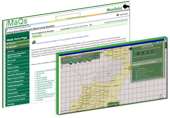
iMaQs is an e-commerce, GIS web-enabled system for mining claim and lease acquisition and administration. It provides robust, secure and powerful geospatial capabilities as well as electronic, graphic and attribute standards.
The Adobe Flex Viewer is leveraged to make iMaQs available through a standard Web browser, and a number of Map Viewers were built to provide easy access to information. Pacific Geotech customized modules that encompass the specific business rules of Manitoba, and the result is a fully-functioning business application that completely integrates with the emerging and existing corporate infrastructure. Members of the mining and prospector communities from around the world can access maps, determine land status, carry out searches and register for their prospecting license. They can view existing claims and leases, roads, rivers, streams, parks and other features to determine where to locate a claim and overlay geology to pinpoint geological hotspots. Once a land acquisition is confirmed, the user can make a secure payment, and the new claim is represented on a map.
Results
The switch to an online map staking system will modernize Manitoba’s mining claim staking process, fostering greater administrative efficiencies for both the government and the industry. Using an Integrated Spatial Repository (ISR), digital base maps are managed with attribute information and meet emerging standards for warehousing data. These data sets are integrated with other online resources to secure claims. This efficiently completes the streamlining of the entire claim acquisition process, enabling a swifter resolution of disposition conflicts, expedited referrals and faster issuance. Payments will also be made securely online, which further reduces processing time. This means that companies can spend less time on acquisition and maintenance and focus more of their resources and energies on the exploration stages.
iMaQs supports the development of better, more productive relations with private landholders and Aboriginal communities by removing a major source of friction, as prospectors do not have to disturb the land to stake their claims. In addition to enhancing communication through public access to information about land staking activities throughout the province, it encourages global business development by allowing anyone with a license, regardless of location, to stake a claim. This means that independent prospectors and junior exploration companies have access to land that may otherwise be too difficult or costly to stake.